By Nicholas Edwards, Technical Project Lead Asia
A squad has just returned from a patrol within their area of operations, a heavily jungled region with an active insurgency that their task force is assigned with first containing and then degrading. In their patrol debriefing to the Intelligence Officer, they describe what matches the descriptions of camps that the insurgency group has been constructing within clearings in the jungle in recent months. With terrorist attacks within the region increasing in frequency and intensity, the order is given to plan an operation to clear the camp before the insurgents have time to reinforce their position.
In this fictional example, VBS4 will be used to plan this mission, helping the command staff to analyze the situation, determine potential courses of action, and test those courses of action to inform the final decision of the commander. This blog will show how VBS4 fits seamlessly into the command staff’s planning cycle, offering significant visualization benefits (that would not be possible with simple 2D maps), the ability to test and evaluate courses of action (COAs) with advanced AI, and tools to evaluate COAs in after-action review. The example shown also demonstrates how a single member of the command staff alone is able to rapidly achieve these outcomes within a couple of hours, illustrating how VBS4 can be a force multiplier for mission planning in even the most demanding of timescales.
VBS4’s whole earth
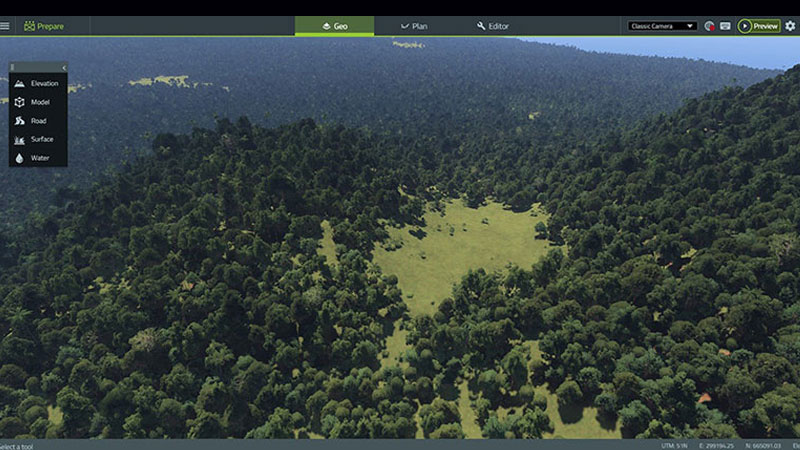
With VBS4 running on a commercial PC, the operator has the entire earth already available, allowing them to quickly zoom to the coordinates in the patrol debriefing report. The command staff planning the mission immediately have a full 3D visualization of the area the patrol passed through.
The operator creates a new Battlespace at the reported insurgent camp coordinates and is ready to prepare the ground. The operator is able to appreciate the ground within moments of launching the software and rapidly add to any existing imagery they have, immediately improving their situational awareness.
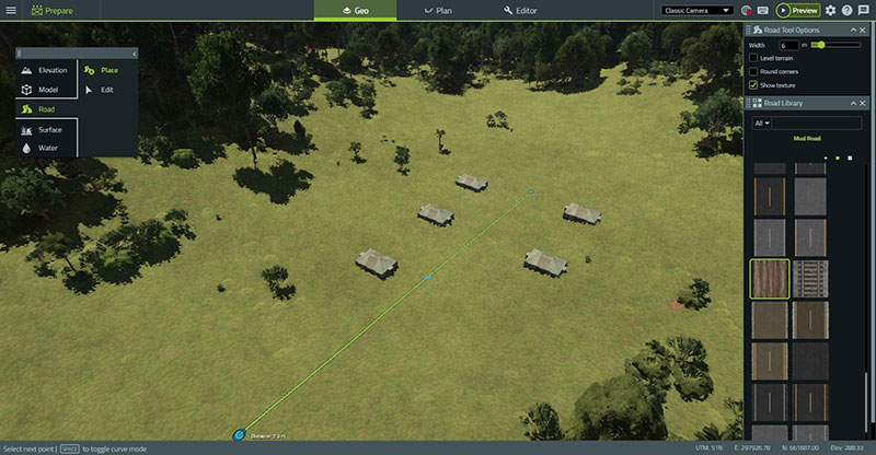
Based on the patrol report and UAV imagery, the operator begins to recreate the terrorist camp in VBS4
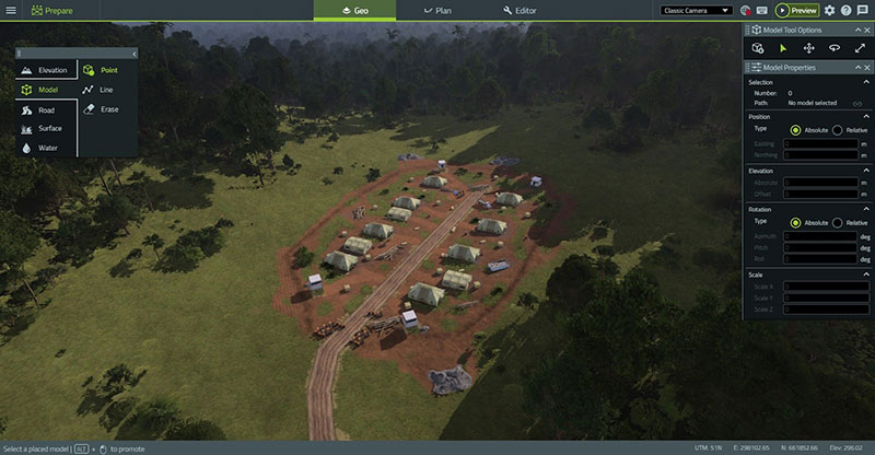
The final result. The operator in less than an hour was able to recreate the camp in extremely high fidelity, including the smaller signs of life recognized in the imagery
Using VBS4’s Geo mode to input the latest intelligence of the ground
VBS Geo is a mode of VBS4 that allows an operator to draw new buildings, roads, trees, lakes, and other features onto the map that might be missing from the basic VBS4 data. VBS Geo is designed so that anyone can be quickly taught to use it, requiring just simple, intuitive inputs to draw the new additions rapidly.
With Geo the operator can begin to visualize the reported camp itself in full 3D. They take the rough sketch from the patrol report and description from the patrol leader and rapidly use Geo to place the tents, represent the dirt from where the ground has been disturbed, draw the barbed wire that will impede movement, and create the dirt tracks that the insurgents created when they moved into the location.
With Geo, the operator can ensure that mission planning is done against the latest intelligence rather than a representation of the area of interest that may be months or even years out of date. Traditionally this would mean paying for a technical developer to rebuild the terrain, having to send sensitive information, and with a lead time too long for time-sensitive mission planning. Geo is simple enough to allow the average soldier to input sensitive information themselves, in minutes, able to keep VBS4 synchronized with the area of interest.
Defining courses of action with VBS Plan
With the area of interest now matching the latest patrol debriefing, the operator now moves onto the second tool in his arsenal. Without leaving the VBS4 application, accessing the VBS Plan mode allows the operator to draw tactical map markings and maneuvers directly onto the 3D environment, along with placing the forces that will conduct these orders.
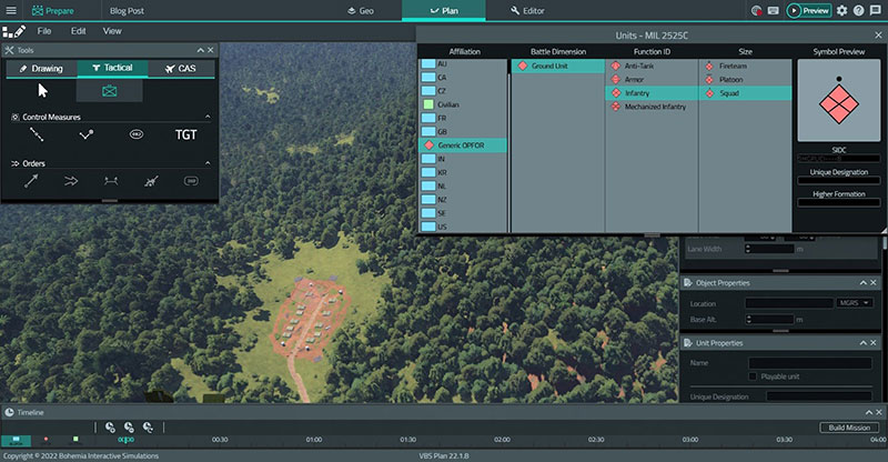
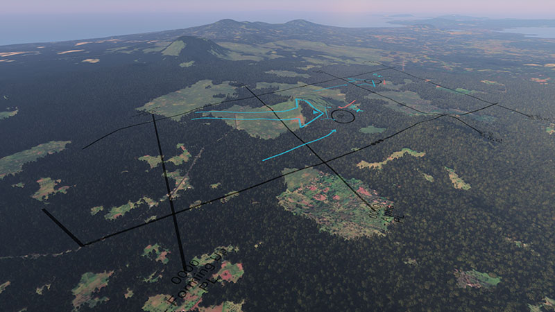
The operator uses VBS Plan to add the reported OPFOR into the camp fully recreating the assessed real-world situation in the virtual world ready to be planned against
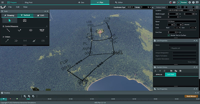
The operator adds the assigned boundaries to the operation, with the ability to render this in 3D, the planning team can far more easily take the terrain picture into account
The method of using VBS Plan to add the BLUFOR (friendly forces) and assessed OPFOR (opposing forces) formations, the boundaries and phase lines that they will be bound by, and the orders that they will execute is designed to match the same process as on a physical map. The operator simply selects the formation filtered by nationality, type, and size and clicks on the map with their location to rapidly lay out the order of battle (ORBATs) of each side on the terrain. A NATO standard map marking can as such easily be selected and the location of the formation set with a mouse click. Following this, the boundaries and phase lines for the operation defined by higher command can be individually selected and drawn onto the terrain directly with the mouse with the ability to add points to bend them along the contours, routes, or natural features that they follow precisely.
The briefing report made note of eight insurgents seen occupying the camp and so the operator places down a squad of insurgents to fill this role with the camp they built in VBS Geo. The operator also draws onto the map the designated boundaries for the mission following the terrain, adds relevant map markings, and fully prepares the virtual environment to match the markings from the physical maps.
With VBS Plan, in comparison to simply denoting these markings on a 2D map, the additional benefits of seeing those markings overlaid in 3D helps to better appreciate the relation of them to this topography. Not only can the command staff review the ground in more detail and from all angles, but they can test the potential outcomes of each of these COAs using VBS4’s advanced Control AI once the planning team have formulated them.
Aligning time and weather
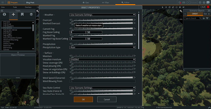
Once the terrain editing and lay down of forces is complete, the operator can use the Scenario settings to configure the scene to match the exact weather conditions that are forecast for the operation, ensuring that aspects such as visibility from cloud cover, fog, rain etc. are visualized (and simulated). The time and date can also be set with VBS4 accurately displaying the level of sunlight, sunrise and sunset times, and moon state as would be seen at those coordinates on that date. The effects of the light levels, impact of sun angles, and weather can therefore be visualized and appreciated in ways not possible through just the use of a 2D map with a weather forecast. VBS4, therefore, offers mission planners a level of environment visualization that would be impossible elsewhere, gaining insights that traditional 2D map study would not have revealed.
VBS4’s Scenario settings allow for the predicted weather and daylight conditions to be recreated, allowing mission planners to assess the impact of adverse weather on aspects such as visibility
The operator uses VBS Plan to add the reported OPFOR into the camp fully recreating the assessed real-world situation in the virtual world ready to be planned against
The command planning team now has a 3D virtual environment perfect for mission planning:
- Through VBS Geo the virtual representation of the insurgent camp and local area reflects the very latest intelligence reports, ensuring that mission planning is done on the best possible representation of the mission environment.
- Any map markings present on the physical 2D mapping have been recreated within VBS4 allowing them to be displayed in both 2D and 3D views, offering operational context to the view of the virtual environment and the ability to assess the suitability of the markings in relation to 3D geographic features.
- Weather and light levels are accurately simulated, offering the command staff an appreciation of the effect well in excess of a simple weather report.
- Both 2D and 3D camera views of the environment are available to command staff. Full control of the camera view, allowing them to see the area of operations from any angle. Line of sight, terrain profiles, tree density, and other aspects of the environment that affect operations.
Returning to the planning cycle
The command staff now goes through their traditional planning procedures in formulating their COAs with increased understanding from the additional insight provided by the VBS4 virtual environment. The intelligence cell uses this 3D representation of the terrain and OPFOR dispositions to help form their assessment of the most likely and most dangerous OPFOR COAs they present to the commander.
In response to the briefing from the intelligence cell, the command staff proposes two BLUFOR courses of action to present to the commander. The first COA is a direct infantry assault on the camp supported by mortar fire to be undertaken by a local infantry platoon, the second is an air strike on the camp. A direct assault has less chance of collateral damage and requires fewer resources, but is riskier, the air strike is more resource-intensive and has a higher collateral damage risk, but far less risk to BLUFOR personnel.
Testing the viability of the courses of action
With VBS4, the command staff is also able to test these COAs and see the potential outcomes, risks, and downsides
The operator is able to test each COA rapidly in a matter of minutes with VBS4 using the VBS Plan mode , and returning to the already-created Battlespace they commence testing the first COA.
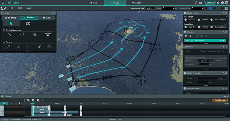
The first COA is redeveloped in VBS Plan. A basic platoon attack with the reserve squad a tactical bound behind. Four phase lines have been added, a Forming-Up Point, a first phase line to coordinate the change in the direction of advance, a second phase line to denote when the assault will begin, and a Line of Exploitation. Boundaries have been positioned based on the frontage of the BLUFOR formations. The planning team can see from the 3D view that the viability of an attack uphill will require further consideration
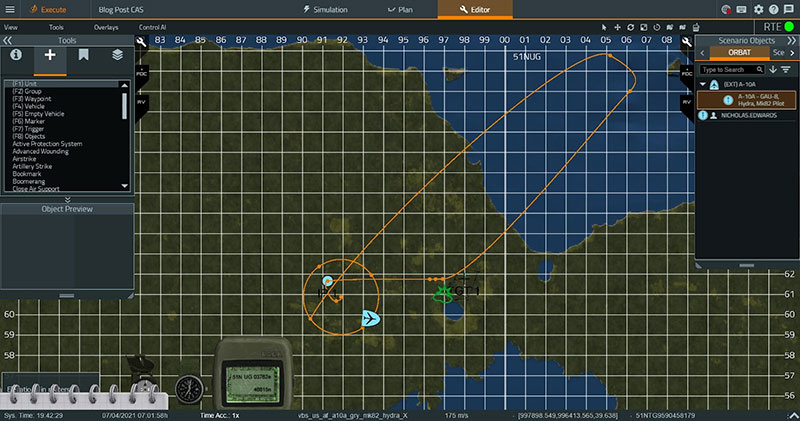
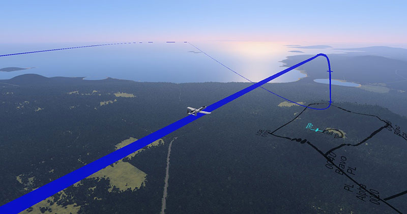
The second COA is developed with the holding pattern, approach, and egress defined
Using VBS Plan the operator is able to quickly add three infantry squads and their mortar attachment simply by placing the infantry platoon symbol assigned to the mission with each of these formations maybe be assigned orders that follow standard NATO symbology. The operator then can “build” the mission and VBS Plan turns the COA into AI behaviors that converts the formations and their orders into individual AI entities that follow pre-defined doctrinal actions using VBS4’s Control AI technology. The operator gives the platoon the same orders prescribed in the first COA, everyone to form up at the first phase line followed by one squad to assault, the second will move to the flank and support by fire, and the third acting as the reserve. Using the fire planning capability the mortar team is then given target coordinates and a time to prepare their fires.
The operator tries out several variations to help evaluate potential alternatives, changing the direction of the Assault, the angle of the supporting fire, whether the mortar fire is beneficial or if a surprise assault might be better. Using VBS Plan these variations can be created and tested rapidly, with the operator and the rest of the planning team able to run each COA and its variations to evaluate and compare the outcomes of each to assist their recommendation to the commander.
The command staff now moves on to testing the second COA. Using VBS Plan the operator places a ground attack aircraft and designates the insurgent camp as a target with a single squad of infantry assigned to occupy and clear the camp in the aftermath of the aircraft strike.
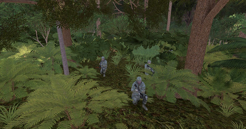
Both courses of action can be tested and recorded by VBS4 from H hour to extraction. VBS4’s Control AI ensures that the virtual soldiers follow doctrine, maneuver in a militarily correct manner, find cover, and engage as a squad against OPFOR targets.
The first COA is tested as the virtual soldiers advance towards each phas line through the jungle. The VBS4 3D view shows that the cover will be excellent
With both courses of action executed, the VBS4 After Action Review (AAR) can then be used to replay the outcomes to the command staff. The entire execution can be watched from any angle, replayed from any point during execution as many times as required, down to seeing the perspective of the individual rifleman. Casualties, ammunition expenditure, timing of significant events are all tracked and the data is available to the operator to help judge the viability of a course of action. The command staff now have pertinent data through which to judge their COAs, test which approaches may have a higher chance of success and which may include unacceptable risks. By allowing risks, misjudgments, and potential points of failure to be discovered virtually and not during the mission itself, the command staff can ensure higher odds of mission success while minimizing BLUFOR casualties and collateral damage.
VBS4 - A force multiplier for mission planning
Ultimately, VBS4 not only fits seamlessly into the mission planning cycle but offers a capability multiplier in comparison to the traditional means available to a command staffs’ planning team. Rather than being bound to the limitations and inflexibility of 2D maps, hand-drawn symbology, and COA assessment based purely on judgment, VBS4 offers:
- A whole earth representation of out of the box, ensuring that mission planning can take place at the exact location on earth where the operation will take place.
- A comprehensive toolset to rapidly modify the area of operations to ensure it matches the latest intelligence through VBS Geo.
- Advanced mission planning tools with the VBS Plan, allowing for the placement of formations, orders, boundaries, phase lines, fire mission coordinates, and other map marking capabilities, visualized in 3D providing a greater appreciation of the ground.
- VBS Control AI technology allows for COAs to be tested by AI soldiers that follow VBS Plan orders doctrinally, offering greater evidence of potential mission success for COA assessment and grading
- Fine-tuning the environmental and scenario details through the VBS Editor, allowing the forecast weather and light conditions, and their effect on the operation, to be visualized and assessed.
- The ability to record, replay, and review each COA through the VBS AAR, providing the capability to study each in detail and consider every aspect repeatedly, highlight discussion points, and as a presentation tool to the commander.
Furthermore, not only does VBS4 offer these benefits but is designed to both be simple enough for an average user to achieve within a short timespan. The example above showcases what an operator with basic training can achieve within even tight cycles, ensuring that VBS4 becomes an indispensable part of the mission planning process.
If you’d like a demonstration, or to know more, you just need to contact sales@bisimulations.com, and we’d love to show you more. To get the latest company updates and news right in your inbox, sign up for BISim's Newsletter.

